


April 25 History Program: "Shop Talk: History & Memories of the Milwaukee Road Shops in Tomah"
The Monroe County Local History Room & Museum presents: “Shop Talk: History & Memories of the Milwaukee Road Shops in Tomah,” a public program to be held on Thursday, April 25th at 7pm at the Sparta United Methodist Church...
History Room closed Jan. 16-22. Reopens Jan. 23.
The Monroe County Local History Room & Museum will be closed to the public from January 16 through January 22, 2024 for exhibit changing and seasonal maintenance...
|
|
 |
Gift Shop
DVDs & Gifts | Genealogy Books | History Books | Rare & Out-of-Print Books | City Directories | Plat Books & Historic Maps | Sparta Spartan Quarterlies (1905-1914) | Sparta Spartan Yearbooks (1915-1939) | Sparta Spartan Yearbooks (1940 on) | Tomah Hamot Yearbooks | Other Monroe County School Yearbooks
|
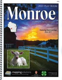
2023 Land Atlas & Plat Book - Monroe County Wisconsin
A useful tool for researchers, pick up a copy of the most recent Plat Book for Monroe County, WI. Detailed, spiral bound atlas showing public and private land ownership, as well as excellent road detail for the county. An ownership index in the back of each atlas makes finding names a snap. Road Index also included. Additionally, this version includes reproduced maps from the 1877 Monroe County Plat Map as well as select historical photos of railroad scenes from throughout the county. 134 pages.
$34.95
|
|
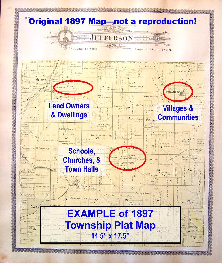
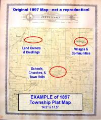
1897 Township Maps - ORIGINAL - suitable for framing
Own a piece of Monroe County History! Townships available: Adrian, Angelo, Byron (Scott), Clifton, Glendale, Greenfield, Jefferson, LaFayette, LaGrange, Leon, Lincoln (Grant), Little Falls, New Lyme, Oakdale, Portland, Ridgeville, Sheldon, Sparta, Tomah, Wellington, Wells, Wilton. These are ORIGINAL 14.5" x 17.5" maps of Monroe Co townships published in 1897 by Geo. A. Ogle & Co.--not a reproduction. Features land owners, villages, communities, residences, churches, town halls, cemeteries, and more. Map paper is aged with minor wear but definitely suitable for framing. LIMITED NUMBER AVAILABLE. Be sure to email which township you want after placing your order. [this is an extra copy donated as a fundraiser]
$24.95
|

|
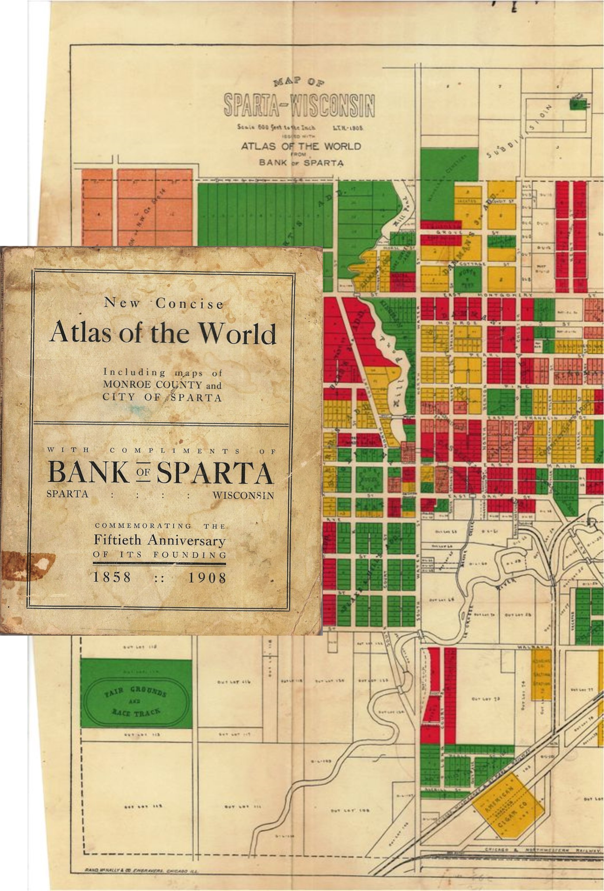
Bank of Sparta 50th Anniversary New Concise Atlas of the World, 1908
Special Edition New Concise Atlas of the World produced with compliments of the Bank of Sparta, Sparta, Wisconsin at the time of its 50th Anniversary, 1908. Atlas published by Rand, McNally & Company. It includes world and state maps as well as a Monroe County map and large pull out colorized map of the City of Sparta. Also includes black and white photos, history, and general information about the Bank of Sparta. Softcover. Cover has some staining and edge wear. Cover and pull out map detached from binding. [Note: This is a duplicate copy sold as a fundraiser for the Local History Room.]
$10.00
|
|
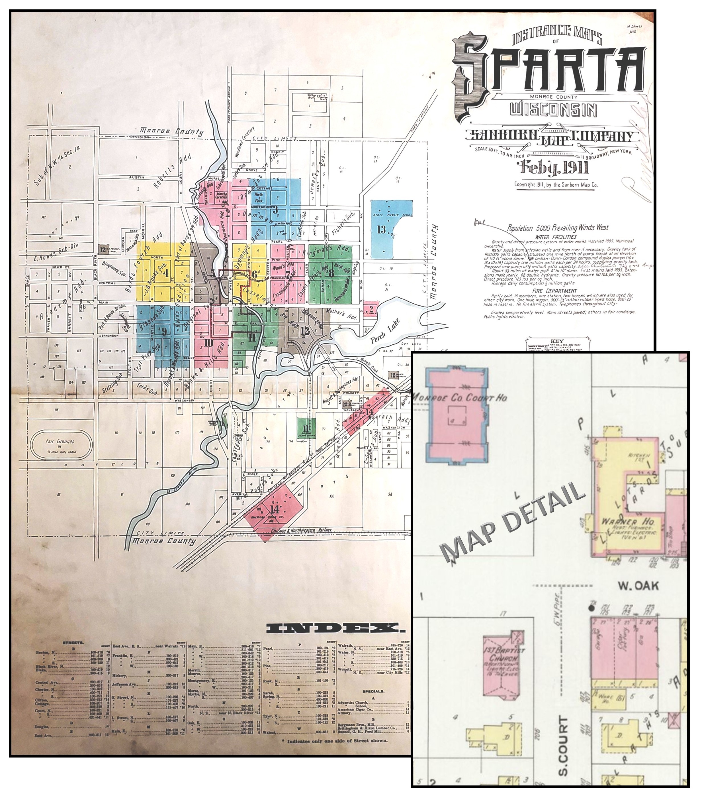
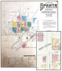
1911 Sanborn Map of Sparta
1911 Sanborn Fire Insurance Map of Sparta, Monroe County, Wisconsin. Sanborn Fire Insurance maps are meticulously detailed, large-scale lithographed, color-keyed street maps. Sanborn Maps helped insurance agents in the late 19th and early 20th centuries determine the degree of fire hazard associated with a particular property. Sanborn Fire Insurance maps typically focus on the business districts within communities but also include residential properties. Each map provides a detailed assessment of the buildings within a district. Assessments include an outline of each building and outbuilding and location of windows and doors.They note the nature of the business or businesses which occupied individual buildings, sometimes even particular room uses.They list the type of construction and the composition of building materials including the framing, flooring, and roofing materials. The publication includes a summary map of the City of Sparta with Street and Business Indexes as well as 13 more detailed maps of street sections and business properties. Map dimensions are 25x21 inches. Map pages in fairly good condition. Cloth cover worn and ink stained. [Note:This is a duplicate copy sold as a fundraiser for the Local History Room.]
$69.95
|
|
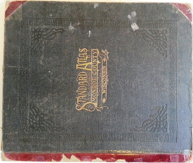
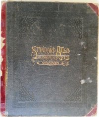
1915 STANDARD ATLAS OF MONROE COUNTY, WISCONSIN
1915 Standard Atlas of Monroe County, Wisconsin. Published by Geo. A. Ogle & Co., Chicago. This original, hard bound book includes • Plat maps of the Villages, Cities, and Townships of the County • Maps of the state, United States, and the world • Patron Directory listing names, addresses, occupations, and year of settlement in the county • Ten pages of black and white photographs of Monroe County people, farms, churches, schools, and businesses • Analysis of the System of US Land Surveys, Digest of the System of Civil Government • Chronology of Ancient, Medieval, and Modern History The book’s contents are in very good condition but the first few pages are loose. The book binding is broken so the cover is loose. Someone used clear tape on the binding in the past. The maps are in very good shape, just some minor staining in some page corners. NOTE: This item was donated to the LHR to sell as a fundraiser since it duplicates superior examples already in the LHR collection. Money raised from the sale of this item directly supports the Local History Room research library.
$79.95
|
|
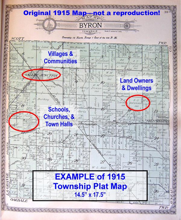
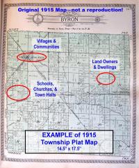
1915 Township Maps - ORIGINAL - suitable for framing
Own a piece of Monroe County History! Townships available: Adrian, Angelo, Byron, Clifton, Glendale, Grant, Greenfield, Jefferson, LaFayette, LaGrange, Leon, Lincoln, Little Falls, New Lyme, Oakdale, Portland, Ridgeville, Scott, Sheldon, Sparta, Tomah, Wellington, Wells, Wilton. These are ORIGINAL 14.5" x 17.5" maps of Monroe Co townships published in 1915 by Geo. A. Ogle & Co.--not a reproduction. Features land owners, villages, communities, residences, churches, town halls, cemeteries, and more. Map paper is aged with minor wear but definitely suitable for framing. LIMITED NUMBER AVAILABLE. Be sure to email which township you want after placing your order. [this is an extra copy donated as a fundraiser]
$24.95
|
|
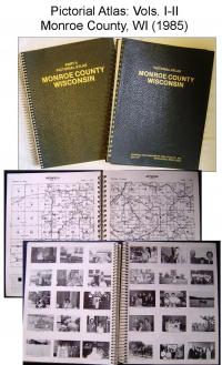
PICTORIAL ATLAS OF MONROE COUNTY, WI: VOLUMES I & II (1985)
1985 Pictorial Atlas of Monroe County, WI: Volumes I & II. Two huge volumes, a combined two inches thick, of county and family histories. Wire bound, leather like covers measuring 10” x 13”. Compiled and published by the Title Atlas Co., Inc. Volume I contains: • Maps of the United States, Wisconsin, Monroe County • Plat maps of Monroe County townships showing land ownership • Patron Index allowing for easy name look ups • Patron Directory providing name, spouse name, children names, occupation, address, length of time in county, etc. Volume II contains: • Photographs of county libraries, churches, schools • Historic photographs of patron ancestors • Studio photographs of patrons and family • Submitted family photographs • Historical sketches of Monroe County townships, communities, villages, churches, places, events, businesses • Family histories • 1915 Plat Book of Monroe County complete reprint. Spiral bound; good condition. [Note: This is an extra copy donated as a fundraiser].
$39.95
|
|
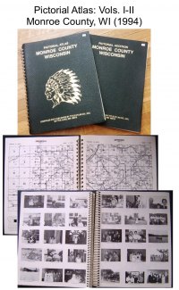
Pictorial Atlas of Monroe County, WI: Volumes I & II (1994)
1994 Pictorial Atlas of Monroe County, WI: Volumes I & II. Two huge volumes, a combined inch and a half thick, of county and family histories. Wire bound, leather like covers measuring 10” x 13”. Compiled and published by the Title Atlas Co., Inc. Volume I contains: • Maps of the United States, Wisconsin, Monroe County • Plat maps of Monroe County townships showing land ownership • Patron Index allowing for easy name look ups • Patron and Township Directories providing name, spouse name, children names, occupation, address, length of time in county, etc. • Brief histories of select government buildings, churches, libraries, businesses, and farms • Reprint of 1897 Monroe County Plat Maps Volume II contains: • Photographs of Monroe County public buildings • Historic photographs of patron ancestors • Studio photographs of patrons and family • Submitted family photographs Excellent condition. [Note: This item was donated to the LHR to sell as a fundraiser since it duplicates superior examples already in the LHR collection. Money raised from the sale of this item directly supports the Local History Room research library].
$39.95
|

|
1997 ATLAS/PLAT BOOK OF MONROE COUNTY, WI
Land Atlas & Plat Book of Monroe County, WI Original plat book published in 1997 by Cloud Cartographics, Inc., St. Cloud, MN. Sponsored by Monroe County 4-H Leaders Association. Contains colored Township maps depicting land owners, roads, highways, etc. Also includes a Land Owner Index, Road Index, General Highway Map of Monroe County, Business Directory, and County Church Directory. Cover is slightly worn; pages in good condition. Soft cover; spiral bound, 64 pages. [Note: this is an extra copy donated as a fundraiser.]
$9.95
|
|
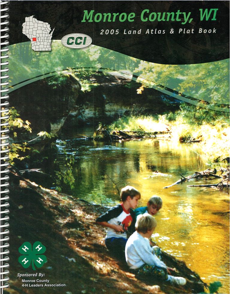
2005 ATLAS/PLAT BOOK OF MONROE COUNTY, WI
Land Atlas & Plat Book of Monroe County, WI Original plat book published in 2005 by Cloud Cartographics, Inc., St. Cloud, MN. Sponsored by Monroe County 4-H Leaders Association. Contains colored Township and City maps depicting land owners, roads, highways, etc. Also includes a Land Owner Index, Road Index, and General Highway Map of Monroe County. Cover and pages in good condition. Soft cover; spiral bound, 98 pages. [Note: this is an extra copy donated as a fundraiser.]
$9.95
|

|
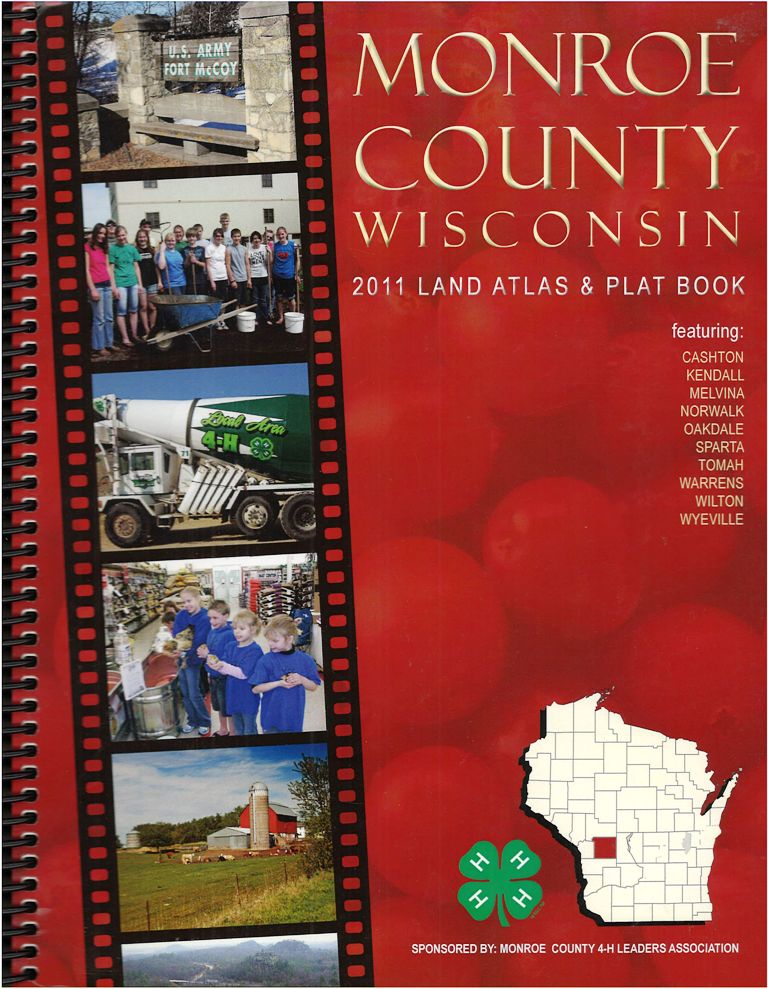
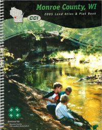
2011 Land Atlas & Plat Book - Monroe County Wisconsin
Detailed, spiral bound atlas showing public and private land ownership, as well as excellent road detail for Monroe County, Wisconsin. New for the 2011 edition are color satellite maps of each township. An ownership index in the back of each atlas makes finding names a snap. 101 pages.
$9.95
|

|
2017 Land Atlas & Plat Book - Monroe County Wisconsin
A useful tool for researchers, pick up a copy of the 2017 Plat Book for Monroe County, WI. Detailed, spiral bound atlas showing public and private land ownership, as well as excellent road detail for Monroe County, Wisconsin. An ownership index in the back of each atlas makes finding names a snap. 112 pages.
$9.95
|

|
2019 Land Atlas & Plat Book - Monroe County Wisconsin
A useful tool for researchers, pick up a copy of the 2019 Plat Book for Monroe County, WI. Detailed, spiral bound atlas showing public and private land ownership, as well as excellent road detail for the county. An ownership index in the back of each atlas makes finding names a snap. Road Index also included. Additionally, this version includes reproduced maps from the 1915 Monroe County Plat Map as well as select historical downtown photos from throughout the county. 140 pages.
$9.95
|
|
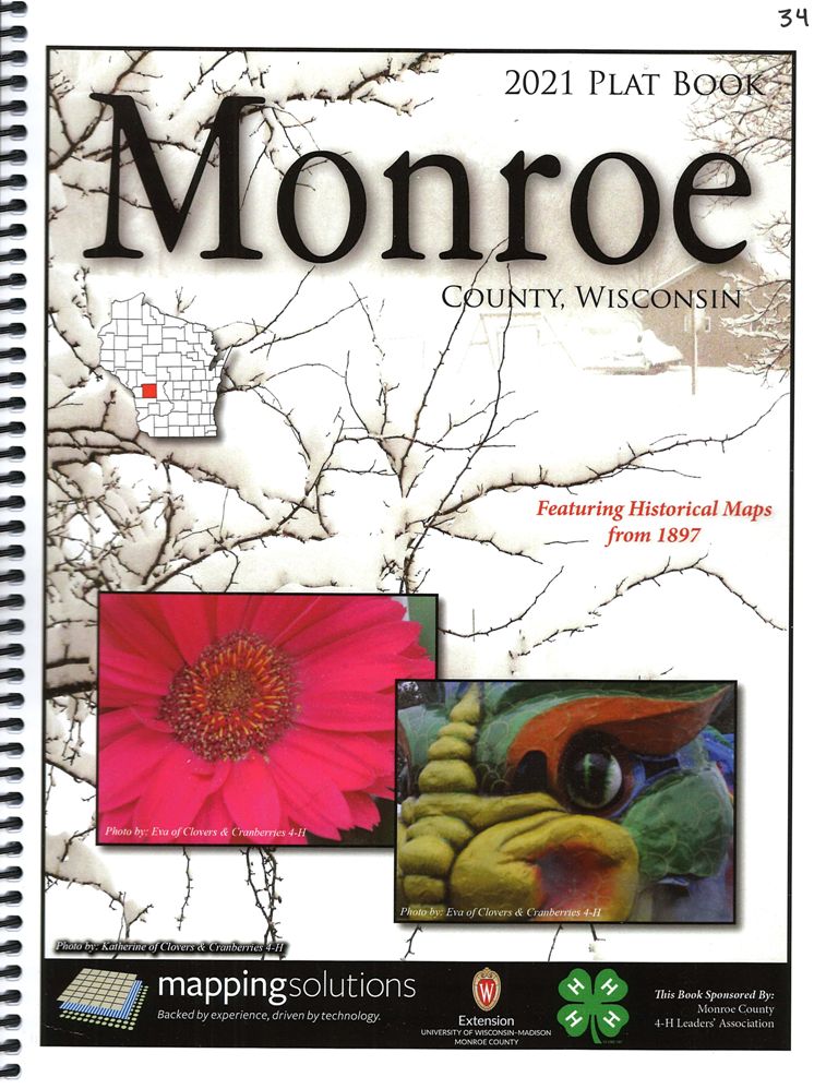
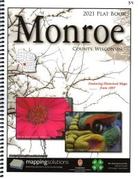
2021 Land Atlas & Plat Book - Monroe County Wisconsin
A useful tool for researchers, pick up a copy of the most recent Plat Book for Monroe County, WI. Detailed, spiral bound atlas showing public and private land ownership, as well as excellent road detail for the county. An ownership index in the back of each atlas makes finding names a snap. Road Index also included. Additionally, this version includes reproduced maps from the 1897 Monroe County Plat Map as well as select historical photos of farming activities from throughout the county. 140 pages.
$9.95
|
|
|